Pages

Saturday, August 1, 2020

Leiper-Smedley-Crum Creek Loop Guide

The Springfield Trail is just one hiking adventure that can be started at Smedley Park. Another loop can be created by combining the Leiper Smedley Trail with the Crum Creek trail. This loop is part paved (Leiper Smedley) and part woods (Crum Creek) trail. I recommend hiking shoes and poles for this one. The woods portion is rocky, full of roots and it's position on the side of the hill between Crum Creek and Swarthmore college makes for some awkward footing in some places. At least it does for me. Don't let that sway you away from this delightful adventure. Forewarned is forearmed. :)

This loop starts at the parking lot by the Penn State Extension in Smedley Park. Enter the park off Baltimore Pike on Paper Mill Road. Turn left just before the trolley tracks; following the sign for the Penn State Extension. Go slow. It's a narrow road and you may meet another car coming out.

[Note about the photos. I used the smallest image. To see more detail, click on the photo and it will enlarge for you]

After parking the car, continue walking out of the parking lot (away from the direction you drove in) toward the Penn State Extension building.  Follow the road to the right (see above)

 And pick up the trail just on the other side of the bollards pictured here.

This short section of trail is taking your towards the Blue Route (476). Note the sign (above) for the Leiper-Smedley Trail (on the right of the photo). It can be confusing as just where that sign appears there is a dirt trail off to your right. Notice, however, that the arrow takes you forward then right. Just past here the trail goes down toward the on ramp to Exit 3 of the Blue Route (476). 
Stay on the side walk which heads left toward the Traffic Light Crossing of Baltimore Pike. Use the designated cross walks to pass safely over the merge to the on ramp; Baltimore Pike; and the off ramp merge onto Baltimore Pike on the other side. 

You are now back on the trail and walking alongside the off ramp from Exit 3 of the Blue Route (476). Stay on the paved trail to Plush Mill Road. Alternatively you can take the dirt trail (see the left of the photo above). It will take you to the same place as the photo below. It's a bit steeper though and prone to blockages. A fun detour if you are up for it though.

Either way you will end up here (above) at Plush Mill Road. At the road you will turn right onto Plush Mill Road. This takes you over the Blue Route (476). 

 On the other side of the Blue Route (476) turn left.

The highway is now on your left and on your right is Wallingford Community Arts Center and Pendle Hill. It's noisy because of the highway (the sound barrier can only do so much) but ignore that and enjoy the glimpses of some fun looking buildings on your right.
 At the end of this section you will turn left to stay on the trail. However, a right turn will take you on to the grounds of the Arts Center and Pendle Hill. There are some interesting paths there through old ruins and mosaic gardens. It's very peaceful. You can put together a nice out and back adventure between here and where you left your car.

Staying on today's tour, however, turning left will take you back over the Blue Route (476) on Rogers Lane. It's actually two lefts. One to get you off the trail and one just after crossing Rogers Lane. Follow Rogers Lane then, over the highway. After the crossing, turn right to stay on the Leiper Smedley Trail. 

You will now follow the trail between the highway on your right and the woods on your left. Today, there was a competition between the Cicadas and the Traffic. In some places, the Cicadas won. :) Highlights of this section are glimpses of Crum Creek and the crumbling ruins of Lytlecote

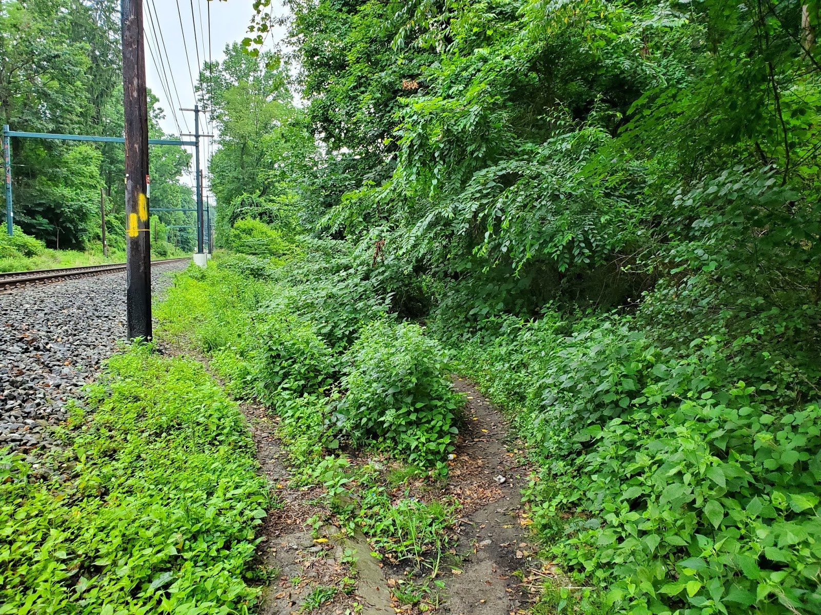
You will also pass under the Septa Media-Elwyn Line. The path here takes a sharp, blind bend. Be aware for cyclists coming the other way. Take a moment on the other side of the underpass to learn about the Crum Creek Viaduct. The path-side information sign gives much more information than any link I could find on the Internet. 

 The trail will eventually bring you down to Avondale Road. You will pass under the highway and at the stop sign carefully cross over to pick up the trail on the other side. There is parking here just to the left off Avondale Road.

Avondale Road can be busy at times and parts of the trail are no more than a wide shoulder off the road (as shown above). However, it is wide and safe enough to travel. You now meet up with Rose Valley Road. 

At this juncture, turn left to continue our loop. However, make note that if you turn right onto Rose Valley road you can continue on to the Thomas Leiper House. If you park in the space where the Trail meets Avondale road it's just a short walk to the Leiper House. I don't know if it's open during COVID but it is a nice tour if you like to learn about Delaware County history. 

 To continue our loop we leave the Leiper  Smedley Trail and follow Avondale road to the left. You will walk a short distance on the shoulder of the road then up on to the sidewalk pictured above.

 You are heading toward the Crum Creek Trail portion of the loop. However, there are no signs. You have to know it's there. Following the road (on the sidewalk) a short distance ....

... you will see the slightly worn path off to your left. The creek is on your left as well and when the creek turns 'inland' you should follow it. It won't take long for the slightly worn path to become a fully obvious trail. Until then, you may feel uncertain. Don't be. If you come to the high rise apartment building you went just a tad too far on Avondale. 


You are now on the Crum Creek Trail. It's mostly dirt, rocks, roots and greenery. You will see a lot of markers such as the one pictured above. I haven't figured out what they mean. Although I imagine they were placed there by (and mean something to) Swarthmore College & Arboretum. 

There are no blazes along this trail and many many dirt trails wander off here and there. Most of them will take you up or down the side of the hill between the creek and the college. Keep the creek on your left and you will be headed the right direction. Explore the side trails for some interesting views. The worst that can happen on the side trails is you'll end up on the college campus. 

Enjoy this section. The views of the creek are amazing. However, don't neglect the woods either. The rock formations (although not as photogenic perhaps as the creek) are beautiful. 

The trail will eventually bring you out to a big meadow with lots of little trails in and out of the wildflowers growing there. When you reach the Septa Line again you will need to head UP to go under the tracks and then the trail will veer up and to the right. It will follow the line of the tracks for a bit before veering off the left to the join the path of the creek again. 

The trail will bring you out to Plush Mill Road again -- down the hill and around the bend from where the Leiper-Smedley portion of this loop crossed Plush Mill Road earlier. 

Turn left on Plush Mill Road to cross over the creek. Be careful the cars coming toward you are coming around a sharp bend. It's safer to cross the street first then walk across the creek. 

 On the other side of the creek notice the yellow blaze on the guard rail. Turn right here....

 ... and follow the path into the woods again. There are no extra trails wandering off in this section. The creek will be on your right now.

 It's a bit rocky here but eventually the path lead you under Baltimore Pike....

And on the other side of Baltimore Pike you are back in Smedley Park. Follow the dirt path through the grass. There will be a ball field backstop on your left.

Just past the backstop look for these steps on your left. Head toward them.

 The steps do not lead anywhere but they alert you to the existence of this trail that will take you back to the parking lot where we started this adventure.

The white building at the top of the hill is the Penn State Extension where we started. To the right of that is the parking lot. 

I was able to map this loop in MapMyWalk.com. Here is the link. It's a little over 4 miles. If you are in the mood for a pleasant long hike, you can combine this with the Springfield Trail Loop for a 9+ mile adventure. 

To connect to the Springfield Trail from this hike, instead of heading toward the steps above continue across the field to Paper Mill Road and pick up the Springfield Trail on the just across the trolley tracks. 

Keep Smiling Keep Moving 
-Paula 

Friday, July 24, 2020

Pandemic Baseball

Last night Baseball returned. Sort of.

A very brave, mask wearing, Dr. Anthony Fauci threw out the first pitch to kick off a new season with new pandemic inspired rules. And, finally, after months of speculation and negotiation, in a rain shortened game, the Yankees beat the Nationals 4-1.

I've been debating whether I will watch the new season. The Phillies open their season tonight against the Marlins at Citizens Bank Park. No fans, no crying and no spitting allowed. It's not the new rules, the piped in noise, or the shortened schedule that bothered me though. It's the money grab.

My initial reaction to the announcement that a 2020 season would happen was annoyance. It's all about the money, I said. The TV revenues is what they are really after, I thought. The rules allowed players to opt out under certain conditions. And some players with big names and solid careers are doing just that. What about the little guy, I wondered? What about the ones trying to make their name and solidify their position? Do they really have a choice? It really bugged me for awhile and I know that my tiny personal boycott would not make any difference ---- except to me.

Then I realized that my indignation was hypocritical. I still go to work every day. And that's about the money, too. I need a paycheck (and a sense of purpose). I shut down like the rest of PA for a long while. And when allowed to return, I began to feel my way toward doing the things (I believe) can be done safely. For my own safety and that of others. Although I believe I am careful there is no way to know for certain that what I'm doing is enough.

Just because MLB is bigger and makes more money than me doesn't mean they should be held to a different standard. MLB shut down too. And when allowed to return they began to work their way toward returning to the field. Yes, they need the money. As do we all.

After getting over myself and my distress, I realized that the return of baseball can do a lot of good for many. Not everyone loves baseball. But for the many that do, this may be a chance to reconnect.  We can't go to the stadium and we shouldn't gather together in large groups but we can - as we've done with everything else for months now - participate together alone. And if you are a Phillies fan you know value of High Hopes.

Go Phils.

Keep Smiling Keep Moving
- Paula


Friday, July 17, 2020

Springfield Trail Guide

Warning: This may be the first and only one of these I do because life is short and my mind takes shortcuts, detours and left-turns-without-signaling on a regular basis. That being said, today I hiked the Springfield Trail and decided to create a guide for you.

The Springfield Trail is a 5-ish mile loop trail in and around Springfield (Delaware County) PA. I like to start it at Smedley Park but there are several trail head options. The trail itself does not have a website but the Smedley Park site has a page dedicated to the Springlfield Trail.

Enter Smedly Park off Baltimore Pike at Paper Mill Road. Paper Mill Road is between the Springfield Mall and the Blue Route (476) entrance off Baltimore Pike.


Travel the park road across the Paper Mill trolley stop and crossing to a parking area on the left. This photo is looking back at the way I drove in. My car is behind me to my right. I chose to do the trail counter clockwise today. The entrance is just to my left.


The Springfield Trail is marked with Yellow Blazes. The first section between the Paper Mill trolley stop and Route 320 is quite narrow in spots. There are lots of deer in the area. Long pants or tick repellent (or both) are recommended. The vegetation was very wet on this humid morning, the long pants also kept me legs drier than they would have been without. 

This first section follows Whiskey Run and the trolley tracks from the Paper Mill Station to the 320 Station (Sproul Road). Just before arriving at 320 you can see the edge of the Springfield Mall parking lot up on the ridge to your right. According to this paper found at DelawareCountyHistory.com, Whiskey Run is "a tributary of Crum Creek, large enough to have had located along its banks several mills powered by its flow." None of the mills still exist, of course, but it's easy to imagine them there. 

Arriving at Route 320 the trail leaves the woods for a short road section.
Springfield Mall and Baltimore pike are to the right (South on 320). To follow the trail turn right.  

The short road section takes you across the trolley tracks on the 320 overpass.
There is a yellow marker on the overpass wall.
And this one (center right) alerts you that the trail goes down the steps. 

And if you aren't sure the yellow markers continue down the stairs
The stairs are narrow and steeper than they look. Watch your step! 

At the bottom you will turn right and follow the tracks just past the overpass.
You are now walking under the road you just used to cross over.
Stay to the right - hug the wall - this is an active trolley line. 

Just past the 320 overpass the trail goes off to the right.
The blazes on the utility poll signal right turn. 
For those unfamiliar with trail blazes a double blaze usually signals a turn. A right turn will have the upper blaze on the right. A left turn will have the upper blaze on the left. 


This next section follows the trolley tracks and Whiskey Run to Thomson Avenue. In the past, I've had to scramble over large fallen trees in this section. Today it was all clear. At the bridge (see above photo) turn left (see the blazes on the tree) At the other side of the bridge turn right. 
Although you won't know it till you get to the intersection - this is Stidman Drive. A short street with some nice looking quadruplex houses. Stidman Drive will bring you out to Thomson Avenue. 


 At Thomson Avenue turn left and go up the hill to Lewis Road.


At Lewis Road you will turn right. There are no markings that I could find here. You just have to know to go that way.


After turning right on Lewis, you will walk along Lewis for about 2 blocks (You'll cross over Gleaves Road as it jogs across Lewis). Right in the middle of all the houses the trees get thicker and if you look to your right you'll see the Yellow Blaze. 

This next section takes you from Lewis Road to James Lane. It goes up and down and up and down. There are several alternate routes and paths that go off up into people's yards. Don't go into people's yards. They generally won't like that. The alternate paths can be confusing and it is through this section that the trail maintainers have the most trouble keeping the blazes. There are lots of blow downs. There is also a blue blaze bandit that attempts to confuse people. The blue blazes will follow the yellow and then suddenly veer off. In some places the Blue Blaze Bandit covers over the yellow ones. Don't fret. It's pretty much impossible to get lost. If you enter the trail from Lewis Road, you'll have Whiskey Run on your left for a short portion and then after a very obvious creek crossing you keep Whiskey Run on your right and backyards on your left all the way to James Lane. 

Lots of steeper ups and downs through this section. Very pretty scenery with trees and water help to take your mind off that. 

Looking up at James Lane as the trail heads up away from Whiskey Creek

To your right as you approach the James Lane Trail head is Kovacs Funeral Home

At the trail head turn right towards Route 420 (Woodland Ave)
Kovacs Funeral Home remains on our right. 

At intersection of James Lane and 420/Woodland Avenue turn left.
I'm not sure if this is a trail marker or some other road mark
But it was in the right place for a trail marker. 

Continue up (yes UP) route  420 to where it ends at Route 320.
Cross at the light and turn left.
You are now walking South on 320

At this church you are going to turn right.
It recently changed names
so (IMO) it's better to remember the building not the name. 

The right turn at the church is onto Wesley Road.
But don't stay on Wesley. Instead turn right into
the church parking lot. Follow the right edge of the parking lot ....

..... to this trail entrance. The sign tells you that you are in the right place.
The church is to my right and just a little behind now. 
This next section travels through the woods to back to Smedley Park. There are a lot of switchbacks here along with more side trails and paths that lead to people's backyards. Again, don't go into people's backyards. It's bad form, unless you've been invited or have permission. That being said, there are portions of the HorseShoe Trail in our area that DO go through people's backyards but these are clearly marked. 

The switchbacks in this section of the trail make you feel like you are going the wrong way especially when the direction change happens at a fork in the trail. Just stick to the yellow blazes and you'll be fine. Sometimes you have to look down the forks to find the next blaze but you shouldn't have to go far to find the next one. The trail maintainers have done a great job of keeping up with re-blazing necessitated by downed trees. 

The trail goes under the Blue Route (476).....

......Just before popping out at the baseball fields.
Turn right here to go over a bridge toward the baseball fields

Follow the blazes on the park walking path.
The baseball field is straight ahead and
to your left is a playground

Just a few steps and this blaze is telling you to turn left back into the woods. 
The trail meanders on the (south??) side of Smedley Park. It goes under the Blue Route again. The Blue Route bisects the park more or less. The trail dumps you in the playground below. My car is just out of the top right corner of the photo below.


I wore sneakers for this hike. Not any conscious choice. It's been so long since I've done any regular hiking I just didn't think to put on hiking shoes. The sneakers were just fine. The last section does have a lot of tree rooted spots and I would have preferred my hiking shoes there but really I was fine. 


I wore a mask for the entire hike today. I was out early today. Some would say it wasn't necessary since I only saw one other human being on the trail. That's not the point. If we stand a chance of beating COVID, we must get used to wearing masks ALL.THE.TIME when we are outside our homes. (And inside our homes if we invite others in). Scrambling to put them on when someone approaches is not good enough. 

It wasn't hard to keep my mask on. I lifted it a very few times to get a breath at the top of a climb. I need more air at the top of a climb even without a mask. The mask I wear for hiking allows me to put a hydration tube under it easily. If I was using a bottle, I would have lowered or raised it momentarily to drink. Your mask protects me. Please wear it. 

As I hiked today and thought about creating a trail guide, I wondered if I should rate the hike's difficulty so others could make decisions. But decided against that. Easy, moderate, hard (or whatever adjectives one might use) are so personal. And quite frankly a hike that might be hard one day is easier the next day depending on one's mood, nutrition and weather conditions - to name just a few factors. If you want to take a hike take it. And if you are unsure if you are 'up to it' my advice is to hike with people you trust. By that I mean with someone you know has your back if you say "This isn't working for me". Someone who will hike back with you if necessary no questions asked; no judgments. BTW, I'll be that person for anyone who wants to take me up on it. 

I hope you enjoyed this guide to the Springfield Trail. I enjoyed creating it. 

Keep Smiling Keep Moving
-Paula